State by state detail maps for
United States
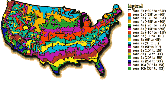
Plant hardiness maps allow producers to label their plants as being suitable for
particular areas, and, in theory at least, this results in happy customers who can
confidently buy plants that will survive in their locality. Early in 1990 the United
States Department of Agriculture (USDA) published an updated version of their map of plant
hardiness zones. This divides the United States into 11 zones (1-11), characterized
by
their average minimum temperature. Zones 2 to 10 are also subdivided into a or b, giving a
total of 20 zones or sub-zones. These zones of course only apply to plants growing out of
doors with no protection, but which are provided with adequate water.
Plant hardiness refers to their ability to survive the conditions of a particular
location, including tolerance of heat, soil moisture, humidity and so on. This map is
based only on how well they survive low temperatures in winter. Even that is a gross
oversimplification. For example, are plants affected more by a single extremely low
temperature night, or is the number of days of frost (the duration of winter) more
important? In fact both are important, but the statistic for the map only relates directly
to the former. Another limitation is that often plants will survive in an area for some
time, but every now and then there will be a catastrophic cold snap that will kill them.
Some risk evaluation - the probability of getting a particularly severe low temperature -
often would be more useful for each locality rather than the average conditions.
Low temperature is not the only determinant of plant survival. Other environmental factors
such as high summer temperature, humidity, soil temperature, etc. may be equally
important. Also, many plants will survive in a locality but won't flower if the
day length is inappropriate or if they require vernalisation (a particular duration of low
temperature). The low temperature statistic is only appropriate for woody perennial
species, and even then its use is limited. With annuals the time of planting can often be
adjusted to allow growth beyond their normal geographical range.
The map is thus only useful as a very broad guide. It needs interpretation that takes into
account factors other than low temperature that limit plant growth as well as local
knowledge.
For an Australian Plant Hardiness Map (which has an excellent overview of Zone
Maps in general), click here.
This article was originally published in 'Australian
Horticulture' 90 (8) 37-39, 1991, when the author was employed by CSIRO Plant Industry.Murray Fagg (murray@anbg.gov.au)
|
