|
|

| About | ~ | Rose Listing | ~ | Rose Gardens | ~ | Old Rose Classifications | ~ | ~ | Glossary |
| Rose Color "Meanings" | ~ | Help Me Find | ~ | USDA Zone Map | ~ | Propagation From Cuttings |
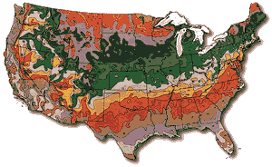
USDA Hardiness Zone Map |
|
|
|
Using the Maps:The USDA Plant Hardiness Zones divide the United States and southern Canada into 11 areas based on a 10 degree Fahrenheit difference in the average annual minimum temperature.A map of the U.S. is the beginning key to selecting the hardiness zone to be used in the search. The maps provided include a detailed, color-coded breakdown by hardiness zone for each state. Zones 2 through 10 have been subdivided into light- and dark- colored sections that represent 5-degree differences WITHIN the 10-degree zone. The lighter color is the colder section; the darker color is the warmer section. These subdivisions are intended to further help the user define the average minimum temperature for his or her area. However, the plant search is conducted on the whole number zone range. If the precise location of your site borders another hardiness zone, you should search twice: first, on the colder zone (lower number), secondly on the warmer zone (higher number). Because cold tolerance is so important, it is better to select plants which will be MORE cold-tolerant rather than less. For example, for a site in zone 7 which borders zone 6: search first for zone 6 plants, secondly on zone 7 plants. |
Compiled, Edited, Programmed and Designed by: ARCADIAN - Real Knowledge Data Network™
(www.RKDN.org)
for information about our Web Design
Services.
Programming and Design ©1997 - 2014 Real Knowledge Data Network.
~All Rights Reserved~
All other trademarks and copyrights remain the property of their respective owners.